
 |
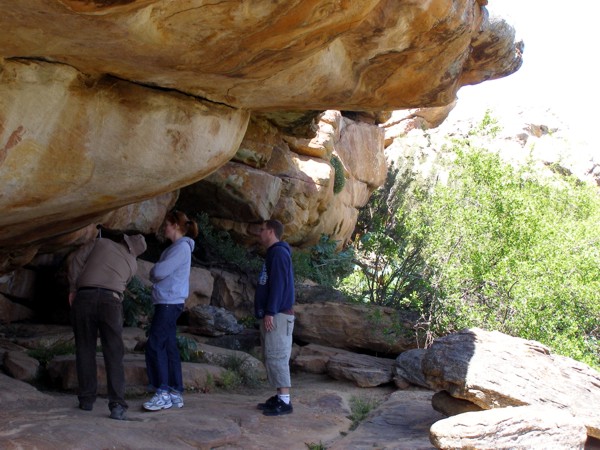
| Studying the rock art at Salmanslaagte |
Salmanslaagte Rock Art Trail : as above + etc etc; a trail from Traveller’s Rest farm that terminates at the Salmanslaagte rock art sites
Sand River : river that arises in Engelsman se Kloof, just north of Sneeukop, and runs down the Vogelgesangvallei and then via the Sand River Canyon, eventually joining the Tra-Tra. The wide valley through which all of this happens is sometimes known as the Wupperthal Kloof; see also Sandrivier below
 |
| Sand River Canyon |
 |
| Ken Howes-Howell's 1948 photo of a car stalled after crossing the Sanddrif |
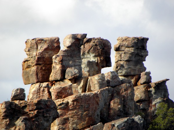 |
| Some impressive rocks near the Sanddrif Crag |
Sandfontein : “sandy spring” [Afr]; a prominent farm in the southern Cederberg owned by the Kotze family; its name has long been associated with the features below
 |
| Sandfontein Arch |
Sandfontein Dam : as above + dam; a large dam west of the Sandfontein farmstead
 |
| Sandfontein Peak: Ken Howes-Howell’s photo from 1952 |
Sandfontein Ravine : as above + ravine; a ravine north of Sandfontein Peak that enters Rietkloof; its position may be incorrect on the current map
 |
| Wynand du Preez’ cottage at Sandhoek |
Sandkamp : “sandy camp” [Afr]; a suburb of Clanwilliam, south of Oukamp
Sandkop : “sandy hill” [Afr]; a 217m hillock east of the Olifants River and across the river from the Suikerbossie farm stall
Sandkraal : “sandy corral” [Afr]; a place on the banks of the Rondegatrivier, between Sandkraalkloof and Wysterskloof, that was once a settlement of ‘riethuise’ occupied by itinerant labourer/farmers who were later moved to the Bosdorp near Algeria
 |
| Sandkraal (moontlik) ... pic by Jannie Nieuwoudt |
Sandkraalkloof : “sandy corral ravine” [Afr]; a small ravine east of the Rondegatrivier and south of the above; there is a cemetery there for the remains of those who once occupied Sandkraal
Sandland : “sandy land or field” [Afr]; a sandy field on the banks of the Wollerivier, south of Heuningvlei
 |
| Some stunning springtime vygies at Sandpoort |
 |
| Sandpoort se Klipgat |
 |
| A great pool on the Sandrivier, near Sanddrif |
 |
| Sandwerf: a landmark on the Wupperthal road |
 |
| One of the great pools and falls at Sas se Hoek |
 |
| Sas se Kloof, looking to the west (with built-in route instructions!) |
 |
| The Sas se Werf cottage at Uitkyk |
Sassies : a bouldering site west of Lorraine farm and named after the cottage for hire there, known as Sassie
Sawadee : a farm off Nieuwoudt’s Pass, on the western side, that was once a resort; the name means ‘hello’ in Thai
 |
| Scenery se Kop is the lower hill on the right; Groot Gang se Kop is the high mountain on the left; Heuningvlei in the foreground |
Scorpion’s Crack : a deep crack on the southern side of Skerpioensberg and north of The Anvil; it is reputed to be the easiest way to ascend the peak, though it has one short slightly tricky chimney section and should not be attempted without an experienced guide
 |
| Secret Falls: all but invisible |
 |
| One of the shelters at Sederhoutkop |
 |
| Surviving cedars at Sederhoutstasie |
Sederville : “cedarville” [Afr]; a suburb of Clanwilliam
Seelandskloof : “sea-lands-ravine” [Afr]; a small ravine north of Kouberg, on the western side of the Tra-Tra mountains, possibly named after a donkey or an ox rather than ‘Zeeland’
Seringboomkraal : “syringa tree corral” [Afr]; an old kraal and nearby graves above the Rondegat river road, between Sandkraal se Kloof and Lela se Kloof
 |
| On the Sevilla Rock Art Trail: approaching Site 3 |
 |
| Sevilla Cottage at Traveller’s Rest |
 |
| Site 5 on the Sevilla Trail, behind a truly ancient olive tree |
 |
| Sewegat se Kloof |
Sewegat se Nek : “seven holes’ nek” [Afr]; a nek south of the ravine above, and probably named after it
Sewevlei : “seven lakes” [Afr]; a kraal on the Tra-Tra Mountain plateau, north of the Citadel. The name possibly refers to the number of shallow, non-perennial pans in the area
 |
| The view south from Shadow Peak, of Langberg and Tafelberg; photo by Graham Bellairs |
 |
| On the Cederberg Shale Band, looking south to Tafelberg, the Spout and Consolation Peak |
 |
| Shaw’s Kloof, looking westwards towards Spitskop, from the Pakhuis Day Walk |
Shepherd’s Hut : an old stone hut near Visgat in the Red Cederberg, south of the Matjiesrivier
Siena se Duik : “Siena’s dip” [Afr]; the first dip in the road to Elizabethsfontein after it has turned off the R364, where by repute a lady named Siena was thrown off the back of a truck as it bounced through the dip. There is a double-entendre in the name because it could also mean ‘Siena’s dive’
Singkop : “sing hill; the hill of singing” [Afr]; a 606m hill just across the Tra-Tra river from the village of Wupperthal from the summit of which carols are sung on Christmas Eve, a ‘musical experience of great beauty’ (Slingsby and Coombe)
Sitkoppie : “little sitting hill” [Afr]; an area of rounded, flattish stones next to the Heuningvlei-Witwater road and almost exactly halfway between the two hamlets; the villagers from each place would meet here on Sunday afternoons to chew the fat and swop news and stories
 |
| Six Drop Falls, from the Agter-Kruis valley |
Skaan se Holte : “Skaan’s hollow” [Afr]; a dip in the Rondegat River road, between Keurbos and Rooidraai. We do not know who Skaan was
 |
| Ken Howes-Howell’s 1931 photo of his mates standing on some of the extraordinarily weathered pinnacles, on Skerpioensberg |
Skerpioenspoort : “scorpion’s pass” [Afr]; the 1423m high nek north of Skerpioensberg, through which passes the path between Boontjieskloof and Crystal Pool
Skeurkrans : “torn cliff” [Afr]; see Die Skeurkrans above
Skeurkrans Day Walk : as above + etc etc; the day walk from Algeria that passes below the Skeurkrans
Skilderklip : “painting rock” [Afr]; an overhang with rock paintings at Tandekop, in the Pakhuis Mountains
Skilderkliphuis : “painting rock house” [Afr]; an overhang with rock paintings in the Kromrivier valley, on the north bank of the Krom River; named by Gerrit Nieuwoudt in 1875 – his name and the date are painted on the cave wall
 |
| Skilpaddorp, with the school in the foreground |
 |
| Skoenmakerspoort, on the road to Eselbank |
Skoongesig : “pretty sight” [Afr]; a 1045m peak north of Kliphuis Peak and south east of Pakhuis Peak, in the Pakhuisberge
Skuinshoog : “at-an-angle rise” [Afr]; there is a small disagreement about this name; some hold that it is the name of the rise in the road between Cederberg Oasis and the Kromrivier/Matjiesrivier junction, at which point there is a turn off left to Kromrivier, while others hold that it is the name of the rise in the road to Kromrivier itself, after it has left the main road. Choose either!
Skurweberg : “rough mountain” [Afr]; a generic name for many mountain peaks and ranges that are extremely rocky and thus have a rough, rugged appearance; this one is a 476m hillock south of the Kriedouwkrans dam, in the western foothills of the Cederberg
Slagkloof : “slaughter or battle ravine” [Afr]; a small ravine south of the Elandskloof settlement; the origin is intriguing but unknown
 |
| Rudolf Andrag’s photo of the ruins of the cottage at Slangboshoek, where Dutch deserters hid during World War II |
 |
| Slangbos, Stoebe plumosa, in the Breekkrans valley; photo by Rudolf Andrag |
 |
| A black Cape cobra near Sas se Hoek |
Slangholte : “snake hollow” [Afr]; a dip in the Rondegat River road between Jamaka and Rooikoppie that also by repute harbors Cape cobras, see above
Slangvlei : “snake marsh or valley” [Afr]; a wetland north of Sederhoutstasie, at the summit of the Uitkyk-Duiwelsgat path
Slanting Rock : a rock on the Mountain Trail at Bushmans Kloof
 |
| Slaweboom is approximately the area where the blue gum trees are, below Bosdorp |
Slaweboom se Hoogte : “slave tree heights” [Afr]; a rise in the Rondegat River road that looks down on Slaweboom
Sleepad : “sled track” [Afr]; a generic term in forestry areas, this one refers to a track north of Heuningvlei used to haul firewood and other commodities on sledges pulled by mules, to the Noodpad to Pakhuis
 |
| Sleepad Hut, looking north west |
Sleepad View Site : as two above + view site; a view site with a fixed telescope situated at the intersection of the Sleepad and the Noodpad, north of Heuningvlei
Slypsteen : “whetstone” [Afr]; an 1187m outcrop resembling a whetstone south east of Zuurvlakte, in the southern Cederberg
Smal se Plek : “Smal’s place” [Afr]; a rock next to the Rondegat River road and close to the Rooidraai cottage where one Smal, a donkey-driver, always rested his donkeys, and sometimes overnighted
Smalberg-Oos : “small mountain east” [Afr]; For many years there has been confusion over the name ‘Smalberg’ on the official maps of the Cederberg. Because the actual peaks are on or close to the overlap between the two sides of the map, the name was frequently incorrectly applied to the wrong peaks. Smalberg-Oos is a 1324m peak that appears as a block-like peak immediately west of the hairpin bend on the Uitkyk Pass
Smalberg-Wes : “small mountain west” [Afr]; see above; Smalberg-Wes is a 1403m peak about 2km west of Smalberg-Oos
 |
| Sneeuberg, from Piekenierskloof Pass: living up to its name in September, 2013 |
 |
| Sneeuberg Hut |
 |
| The Cederberg Sneeukop, living up to its name |
 |
| Sneeukop Hut, the most exposed hut in the Cederberg |
 |
| Soldaatskop, off the Pakhuis Pass |
Sonop : “sunrise” [Afr]; a farm west of the N7, just north of Petersfield
Sonop Motors : as above + motors; a popular filling station across the road from the above
 |
| The famous string of elephants at Upper Sonya’s Cave |
South African War Trenches : two parallel trenches several hundred metres long and built of rough bricks, situated above Onderbaadjie se Draai on the R364, just west of the Englishman’s Grave; we assume these are part of the same fortifications built to guard the Cape from marauding Boer commandoes in about 1901 (see below). These trenches were ‘discovered’ by Koos Strauss, late farmer at Traveller’s Rest; one day he and his labour were burning veld in the area when several old bullets exploded, thus revealing the trenches
 |
| The SA War Blockhouse at Bakleikraal |
 |
| Remains of the SA War Blockhouse at the summit of the Uitkyk Pass; pic and info by Ernst Hartwig |
 |
| SA War Blockhouse in Krakadouw kloof |
South Peak : an 1843m peak south west of Sneeukop, in the Cederberg
Spaansrietkop : “Spanish reed hill” [Afr]; a 624m hillock between Boskloof and Grootkloof; we have been unable to identify the origin of the plant or indeed the name
Speelkloof : “play ravine” [Afr]; a small ravine east of Grasvlei; origin unknown
 |
| The Sphinx, looking towards Tafelberg and Consolation Peak; photo by Ken Howes-Howell, 1934 |
Spinnekop : “spider” [Afr]; a 1615m peak north west of Sandfontein Peak known for the spidery weathering of the summit rocks
 |
| Spinnekop Arch |

 |
| Two Spitskoppe: [top] Spitskop south of Kriedouwkrans; [bottom] perhaps the better-known Spitskop, on the Clanwilliam side of the Pakhuis Pass |
Spoelkloof : “flush or rinse ravine” [Afr]; a ravine with a tributary of the Rondegat River that runs down the eastern flank of Suurvlak se Kop, possibly where wagon drivers took a sip, ie rinsed their mouths, after the long dusty haul up the valley from Algeria
 |
| Spookpoort. Or Rooipoort. Or Oupoort. Your choice. |
 |
| Spout Cave: pic by Graham Bellairs |
 |
| Square Tower: a block of rock. Pic by Graham Bellairs |
 |
| Staan-Staan-Drink |
 |
| The main Stadsaal cave; graffiti on the left go back to the 19th Century |
 |
| Steenrugkloof, near Algeria |
Steenrugkop : “stone ridge peak” [Afr]; a 1310m peak due north of Algeria; mystery surrounds the fact that so many earlier maps spelled the name ‘steemrug’, which has no meaning at all
 |
| Sterrebosbank – the shale band north of Sneeuberg |
 |
| The sterrebos or star bush – Leucadendron nitidum |
 |
| The Stewelklip in Van Zylsgatpoort |
Stinkrivier : “smelly river” [Afr]; a small farm west of the N7, slightly north of the intersection with the R303
Stonehaven : a cottage for hire at Petersfield farm, off the N7 north of Citrusdal
Studenthof : “student garden” [Afr]; an area on the Brandewynrivier upstream of Sevilla and Bloutuin. I have not been able to find any explanation for this name; it appears on official maps but the farm owners at Traveller’s Rest have no knowledge of it
 |
| The Sugarloaf, from the Maltese Cross path |
Suikerberg : “sugar mountain” [Afr]; see above, the Afrikaans name for the same hill
 |
| The ruins at Suikerbergwerf, with Dwarsrivierberg in the distance |
Suikerbossie : “little sugar-bush” [Afr]; a farm stall at Koedoeskop farm on the N7 north of Citrusdal
 |
| Summit Cave on Groot Krakadouw |
Summit Pinnacle : a pinnacle rock at the summit of the Krakadouw pass
 |
| Surings – Oxalis pes-caprae – in the Cederberg |
Suurkop : “sour hill” [Afr]; a 653m hill north of the Pakhuisberg and west of Lorraine farm
Suurlemoenboom : “lemon tree” [Afr]; an abandoned farm on the Boskloofsrivier north of Citrusdal
Suurrug : “sour ridge” [Afr]; a tiny settlement north of Kouberg and east of Heiveldt, on the Wupperthal mission lands
Suurvlak se Kloof : “sour flats ravine” [Afr]; a shallow ravine between Suurvlak se Kop and Vensterberg South through which passes the Kruispad to the Heks River Valley
Suurvlak se Kop : “sour flats hill” [Afr]; a 1618m peak south west of Algeria, also known as Zuurvleiberg
Suurvlakte : “sour flats” [Afr]; a plateau in the southern Cederberg about 1100m above sea level, so-called for its acid (‘sour’) sands which support an unfortunate growth of exotic pine trees
Suurvlakte Peak : as above + peak; a 1451m peak south of Suurvlakte which used to have the (post-apartheid unacceptable) name ‘Kafferkop’
Suurvlakte Ridge : as above + ridge; a ridge of hills that includes the above peak and runs to the south east of Suurvlakte
Suurvlei Dam : “sour marsh” + dam [Afr]; a dam at Suurvlakte, see above
Suurvleirivier : “sour marsh river” [Afr]; the river which runs down from Suurvlakte past Tuinskloof and Ysterplaat farms to join the Middeldeurrivier, in the southern Cederberg
Suurvleistroom : “sour marsh stream” [Afr]; the headwaters of the Suurvleirivier, arising on Hamerkop and running into the suurvlei Dam above
Swart Kliphuis : “black rock-house” [Afr]; a prominent cave on Bain’s Old Road between Kriedouwkrans and Rondegat farms, also referred to by Leipoldt as the ‘Travellers’ Cave’
 |
| Swartgat Hill on the Noodpad, with rising mist over the Agter-Pakhuis |
Swartkrans : “black cliff” [Afr]; a prominent cliff in a side-ravine on the eastern side of the Moordenaarsgat, north of Martiensrus
 |
| Swartpoort, off Amon se Vlak |
 |
| The Swemgat near the Anvil, after a fire |
Swiet se Graf : “Swiet’s grave” [Afr]; Swiet was a buchu collector who died here as a result of sudden acute appendicitis early in the 1900s, and was buried by his companions at this lonely place, on the path between Bakleikraal and Syferfontein
 |
| Sydekel, Tandjiesberg or the Citadel, peeping out above its shale band |
 |
| The curious rock painting at Syfer |
Syfer Dam : as above + dam; a dam near the rock art site above
 |
| Syferfontein, where the farmstead once stood; its removal is regrettable |
No comments:
Post a Comment