
 |
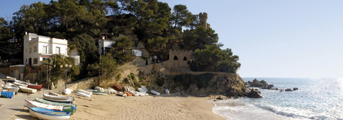
| Sa-Caleta Cove, on the Mediterranean: the website blurb says: ‘Sa Caleta is located next to Lloret Beach. It stretches below a castle that enjoys lovely views. Small boats are clustered along the shore.’ Nice as it is, the Clanwilliam Dam was never like this ... |
Calvinia : Rural town in the Northern Cape Province, at the foot of the Hantam mountains; named after John Calvin, the protestant reformer, in 1851
Camp Sallie : A boulderer’s campsite at the De Pakhuys resort, in the Agter-Pakhuis; origin unknown. Possibly named by a homesick American boulderer after Camp Salie, a resort within the Martin-Island-Linwood Lakes Regional Park in Minnesota?
Cape Leopard Trust Environmental Camp : An environmental education centre for children and adults, originally established by Elizabeth Martins at Matjiesrivier in the Cederberg, and operated under the aegis of the Cape Leopard Trust
 |
| Cape leopard: Panthera pardus |
 |
| Cascade Pools |
Castle Rock : Bouldering site near the summit of the Pakhuis Pass, off Amon se Poort
 |
| Cathedral Rocks |
 |
| Some of the more bizarre rock art figures at Cave Bee cave |
Cedar Peak : A 1691m peak that lies between Krakadouw and Chisel Peak
Cedar Rock : A reserve and resort in the Red Cederberg, on the farm Zuurfontein [“sour spring”, Afr]
 |
| A fine specimen of the Cederberg ‘cedar’, Widdringtonia wallachi; this one was photographed by Ken Howes-Howell near the Middelberg Hut in January 1941. The tree has gone; more significant, if you look closely, are the thousands of young cypress seedlings that surround this giant in all directions. They, too, have gone ... |
Cederberg Cellar : Wine cellar at Dwarsrivier farm in the central Cederberg
Cederberg Cottage : Resort near Kriedouw at the western end of Nieuwoudt’s Pass
Cederberg Heritage Route : An organization that runs a series of guided trails that encourage the participation of the less-advantaged communities of the outlying Wupperthal Mission hamlets as guides, donkey-cart drivers, accommodation and meal providers, etc.
Cederberg Oasis : A resort and restaurant in the eastern Cederberg near the farm Vogelfontein; formerly known as Fontein-Meriba. The latter name comes from the biblical account wherein Moses strikes the rock, causing water to gush from it; ‘meribah’ means ‘the quarrel’, hence ‘spring of the quarrel’
Cederberg Wilderness : Proclaimed on 27 July 1973, the Cederberg Wilderness covers more-or-less the State Forest area known as the Cederberg. Wilderness status (proclaimed in terms of an Act of Parliament) means that the area must be conserved as far as possible in its original condition, etc etc. Whether the status has benefitted the rapidly-disappearing cedar trees is doubtful
Cederfontein Mineral Water Bottling Plant : An abandoned building between Vogelfontein and Grootrivier; it appears to be an enterprise that never took off
 |
| Cederhoutkloof; the view upstream |
Cederhoutkop : “cedarwood hill” [Afr]; a 974m peak in the Pakhuisberge where presumably cedars once grew; there were no cedars there by the 1980s when Rudolf Andrag completed his cedar tree survey
Cederpark : An accommodation facility for farm workers off the R303, near Kunje
Ceres : A major town in the Warm Bokkeveld, on the R303 route to the southern Cederberg. Senator G. Munnik gave the name to the farm he bought in 1854, where the town now stands; Ceres was the Roman goddess of agriculture. The weather forecasting service yr.no provides reports for no less than 86 places named Ceres around the world ....
Chaos : A 1560m+ peak south of Sandfontein Peak in the southern Cederberg, known for its difficult jumble of massive boulders
 |
| Faith, Hope (partly obscured) and Charity (on the right) |
 |
| The line of chubby ladies at Charlie Brown |
Chisel Peak : A 1716m peak south of Cedar Peak and north of Koupoort Peak, on the eastern side of the Clanwilliam Boskloof
 |
| Chockstone; Ferdi Fischer in the view |
 |
| Citadel, Tandjiesberg or Sykadel |
Citadel Kop : As above
Citrusdal : A town on the south western edge of the Cederberg, founded in 1916 on a portion of the farm Middelpost to act as a spiritual and commercial centre for the local farming district.
Citrusdal Air Field : As above; for many years it was a base for the Western Province Parachute Club; with the call sign ‘FACI’, it is currently closed
Citrusdal Cellars : As above; a local cooperative wine cellar
 |
| Clanwilliam, in about 1870; note the gaol at the end of the street [without palm trees!] |
 |
| The Clanwilliam Dam photographed by Ken Howes-Howell in 1958, before the wall was raised by six metres to the present level |
Clay Dam : A small dam at Bushmans Kloof
Consolation Peak : A peak of 1759m south west of the Cederberg Tafelberg, and possibly so named as it is an easier option for those who fail to make the ascent of Tafelberg itself
 |
| Deep cracks on Corridor Peak; photo by Graham Bellairs |
Country House : An accommodation facility outside Citrusdal on its northern side
 |
| Inside the Crack Caverns |
Crevasse Peak : A twin peak of 1606m and 1626m that is divided by a deep crevasse; between Klein-Koupoort and Groot-Koupoort
 |
| Crystal Pool on a dark, spooky afternoon |
 |
| Crystal Pool Hut |
Crystal Pools : A series of pools in the upper reaches of the Boontjieskloof River, outside the Bushmans Kloof boundary; it is unfortunate that the same name as the pool above has been adopted for these by unknown but clearly unimaginative persons
Cyster se Grot : “Cyster’s cave” [Afr]; Cyster was a semi-hermit who reputedly bought the property just south of the present-day Bushmans Kloof from the Wupperthal Mission, for five pounds; thereafter he lived alone in the cave for many years until a house was built for him nearby. He died there in the 1990s when he was more than 100 years old. As the land is now part of the Mission Lands it seems more likely that Cyster merely purchased a lifelong lease rather than the actual property
Cyster se Werf : “Cyster’s place” [Afr]; as above, the house where Cyster died. ‘Cyster’ is pronounced ‘sayster’
No comments:
Post a Comment